
Description
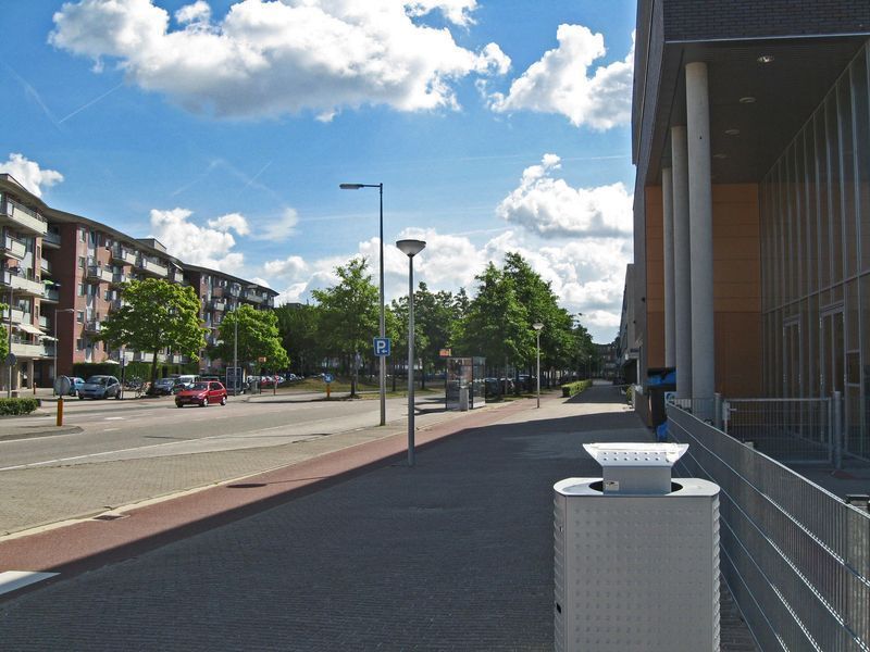
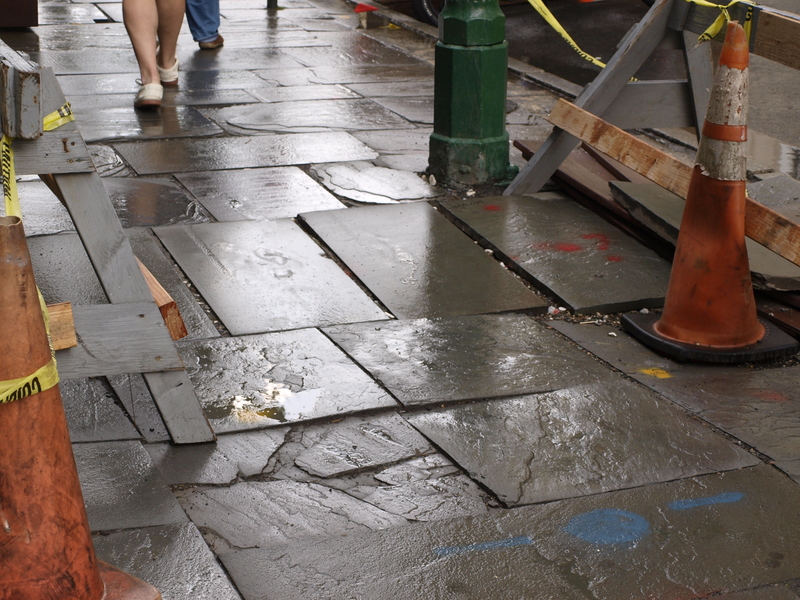
Given Whalley Ave's expansive width and high traffic volumes, and given business owners' desire to transform this space into an urban boulevard from a urban design standpoint, Whalley Avenue from the Fountain St intersection to Broadway would be the ideal location for a European/New York City-style physically separated bike lane. Ideally, this cycle track should spend most time on sidewalk level, as seen in the attached photo.


57 Comments
Brian Tang (Registered User)
Anonymous (Guest)
MIT just built these through their campus and they are fantastic.
Acknowledged Department of Transportation, Traffic and Parking (Registered User)
Brian Tang (Registered User)
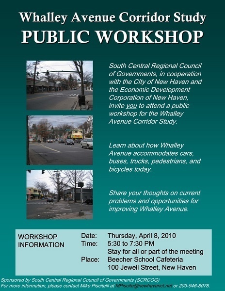
There will be a meeting about the future of Whalley Ave THIS THURSDAY, April 8TH, 5:30–7:30PM at the Beecher School Cafeteria, 100 Jewel Street, New Haven, CT
Flyer:
Public Workshop Planned for the Whalley Avenue Corridor Study
The South Central Regional Council of Governments (SCRCOG), in cooperation with the City of New Haven and the Economic Development Corporation of New Haven, invite you to a public workshop for the Whalley Avenue Corridor Study. The workshop is scheduled for:
Thursday, April 8, 2010 from 5:30 to 7:30 PM at the Beecher School Cafeteria, 100 Jewell Street, New Haven.
The Whalley Avenue Corridor Study is evaluating transportation and related issues along Whalley Avenue between Emerson Street and Broadway in New Haven. The study will result in a conceptual plan that details recommendations to improve traffic movements, pedestrian and bicycle mobility, transit service, and safety in the corridor while supporting economic development and the livability objectives of the local neighborhoods. The study will be completed in summer 2010.
The meeting is an opportunity for the public to learn more about the study and provide input with regard to current issues and potential solutions. Information will be presented through a series of displays, and attendees will additionally have the opportunity to work with planners to discuss conditions and explore opportunities within the corridor. Attendance is welcome for any portion or the entire duration of the workshop, which will include a self-guided displays and ongoing workshop exercises with project team members.
Staff from SCRCOG, the City of New Haven, and the project consultant team will be at the workshop to discuss the study and answer questions.
Please contact Michael Piscitelli via email at mpiscite@newhavenct.net or phone at 203-946-8078 with questions or comments about the study or workshop.
--
Also, I recently ran across this sweet video out of Portland all about cycle tracks:
http://vimeo.com/10559007
This report on cycle tracks from Alta Planning is even more helpful:
http://www.nacto.org/downloads/cycletrack_lessons_learned.pdf
Matthew J. Feiner (Registered User)
CT Livable Streets Campaign (Registered User)
Moses (Guest)
Sarah (Guest)
Brian Tang (Registered User)
Here’s an updated general diagram of what I have in mind. The parking and tree strips could be added or deleted as necessary as the road width changes.
In a few instances, it may be desirable to place the tree strip between the cycle track and sidewalk in order to preserve existing trees.
laura (Guest)
Anonymous (Guest)
Edwin Williamson (Guest)
Anonymous (Guest)
Anonymous (Guest)
Lisa (Guest)
Brian Tang (Guest)
Maz Burbank (Guest)
CT Livable Streets Campaign (Registered User)
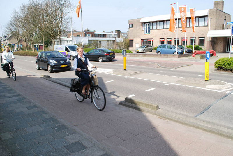
Typical cycle track. Each side is wide enough for two way cycle traffic and pedestrians. All intersections, including driveways, are raised with bollards to prevent vehicles from turning in quickly. Bicycle traffic signals are standard at major intersections and are timed to a typical travel speed; at minor crossings, the traffic calming and raised intersections does the trick.
This is on a two-lane road, also showing a pedestrian median at the crosswalk. To make roads more walkable for pedestrians of all ages and abilities, you should reduce maximum crossing distances to 10 feet or so, and also have crosswalks located at every block.
It's possible to use these same designs on a four-lane road like Whalley Avenue. You just need a slightly wider median area and on a busier street, the cycle track needs to be wider if the amount of cycle traffic is very high.
In many European urban areas, of course, four lane roads like Whalley are not common because the vast majority of trips with the metropolitan region, and an even larger share within the city center, are made by bicycle or public transit (cars as a small minority). Reducing the amount of car trips within an urban area can free up hundreds of acres of urban space for things like parks, playgrounds, plazas, green plantings/swales, trees and new real estate development.
The main benefit of cycle tracks is that users of all ages and abilities, including families and children, will use them. On-road facilities only attract a small number of mostly young, male cyclists. Also, because of the timed bicycle traffic signals and raised intersection improvements, cycle tracks are often a faster way to get across town than either driving or riding your bike in traffic.
CT Livable Streets Campaign (Registered User)
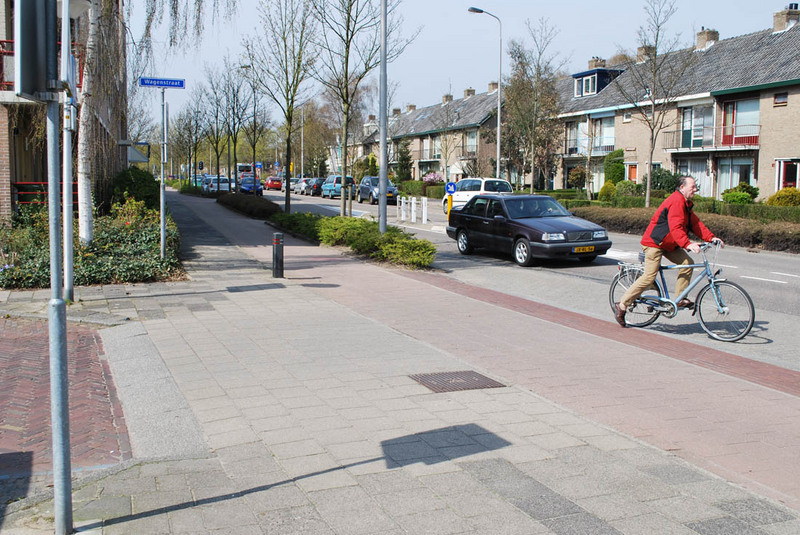
This shows the raised intersection treatment I mentioned above. This is used where the main street crosses driveways and small residential streets (which are all limited to 10-15MPH). Tabled intersections are used at larger intersections; if volume is very high (like it might be at Whalley and Boulevard, for example), you may find a roundabout or signal system. All are used in combination with refuge medians to provide pedestrian safety.
Vehicles coming from either direction must slow down to a crawl before crossing the pedestrian sidewalk and cycle track area, which improves mobility and safety for all road users. Pedestrians and cyclists gain great visibility, especially if they are shorter, because the sidewalk/sidepath area is higher than the street bed. Drivers have to slow before pulling out of the intersection, making crashes far less likely.
This type of treatment should be used all along Whalley, in combination with the new cycle track.
Brian Tang (Registered User)
Comments on the issue entitled “Elm Street Cycle Track” (http://seeclickfix.com/issues/15932) have raised concern that road diets (reduction in the number of through auto lanes) associated with the two cycle track proposals could result in significant traffic delays.
My experience with road diets has indicated that a reduction in the number of through lanes on Whalley Avenue would result in an overall decrease in speeds, particularly during peak hours. During non-peak hours, delays resulting from reduced speeds will be more than offset by improvements in traffic flow resulting from the addition of turnout lanes and turn pockets and from the reduction in frequency of auto collisions (which currently occur unacceptably frequently on Whalley Ave). I would expect noticeable delays during peak hours, at least on some sections of Whalley Ave, as a result of increased queueing at signalized intersections. Thus, I would anticipate some downside to a reduction in the number of lanes on Whalley. However, we must also consider the benefits. Reducing the number of lanes would free up space for measures necessary to reduce accident frequency (dedicated turn pockets with protected left turns at signalized intersections, a center turn-out lane). The space would also permit measures to improve the ability to Whalley Avenue to adequately and safely serve pedestrians and bicyclists. In addition to freeing up space for separated bike paths, a reduction in the number of lanes would allow for raised medians and curb extensions at pedestrian crossings. As illustrated in the photographs from Amsterdam posted by Mark Abraham, the reduction in lane number could also free up space for numerous enhancements to the safety and aesthetics of the environment, as well as additional vegetation, bus shelters, and on-street parking. These opportunities offer substantial benefit to local businesses and people who live, work, commute, or shop along Whalley. Together, these benefits outweigh the costs associated with anticipated traffic delays during peak hours.
As for the possibility of alternate routes for bicyclists, as Mark has observed in his trip to Amsterdam, a road network that is truly accessible to bicycles is one where no prior knowledge of bike routes is necessary in order to safely and comfortably navigate the city on a bicycle. When I visited Amsterdam and rented a bicycle, I too was enthralled by the fact that I could navigate by dead reckoning. I had no knowledge of the road network whatsoever, yet the ubiquitous availability of low-stress bike paths meant that I could set out in any direction and then simply follow the signs back to downtown. There is no reason why our roads should not be equally intuitive to bicyclists. Shoppers and commuters interested in going to or along Whalley Avenue should not have to find an alternate route.
Anonymous (Guest)
Brian Tang (Guest)
The South Central Regional Council of Governments (SCRCOG), in cooperation with the City of New Haven and the Economic Development Corporation of New Haven, invite you to a public open house for the Whalley Avenue Corridor Study.
The meeting is scheduled for:
Monday, June 28, 2010 from 5:30 to 7:30 PM
Village Café, Marrakech,
520 Whalley Avenue, New Haven.
Please attend this meeting and request separated bike paths (cycle tracks) along Whalley. I will unfortunate be out o town.
Jason Stockmann (Registered User)
Fitzgerald and Halliday persists in rejecting cycle tracks and traffic calming measures for Whalley Avenue. This is inconsistent with the Complete Streets legislation that has been passed at both the City and the State level.
Below is an open letter to Fitzgerald and Halliday that I welcome anyone to copy from in drafting their own testimony on this topic. Please submit testimony to:
whalley@fhiplan.com
Remember! F&H is working for we the TAXPAYERS, not the DOT bureaucrats!
==================================
Dear Planning Consultants,
Please consider installing traffic calming measures and bicycle tracks on Whalley Avenue as part of its upcoming overhaul.
Public officials underestimate the impact of bicycle and pedestrian amenities and traffic calming on neighborhood livability, public health, economic vitality, and safety, particularly for vulnerable residents like children and the elderly. When you talk to officials, you hear about the necessity of moving lots of cars quickly. When you talk to people like myself who actually live near Whalley Ave., you hear a completely different story. You don't hear people asking for more vehicle lanes and more car-friendly traffic signal timing. You hear them asking for measures that slow traffic down. You hear them asking for safe on-street bicycle lanes, preferably insulated from traffic by a row of parked cars. You hear them asking for safe intersections where children and the elderly can cross without fear.
New Haven is one of the most pedestrian cities in New England. Tens of thousands of residents live from day to day with little or no use of a car, myself included. You don't even need to *project* future bicycle use to justify inclusion of bike lanes; New Haven already boasts thousands of cyclists across all of its neighborhoods. Present levels of bicycle use more than justify the implementation of "Complete Streets" that include bike tracks. Future bicycling growth is just icing on the cake.
Traffic planning is intimately tied to neighborhood livability, property values, and economic vitality in delicate urban ecosystems such as New Haven. Traffic planning that subjugates all other concerns to the hegemony of the automobile makes neighborhoods less attractive places to shop, live, and play, hurting the city's economic competitiveness. The feature that all of New Haven's most vibrant retail districts share is their relatively narrow streets and pedestrian-friendliness. Just think of Downtown Chapel St. and Crown St., Wooster Street in the Wooster Square neighborhood, or lower Orange Street in the East Rock neighborhood.
Increasing the speed of automobiles greatly augments the rate of pedestrian and cyclist death in accidents while having a very limited effect on the road's actual traffic volume capacity. Cars racing from light to light do not move through the neighborhood faster than cars maintaining a more consistent, neighborhood-friendly speed of 20-25 mph.
I emphasize in closing the benefit your firm would reap from designing a truly Complete Street on Whalley Avenue. Imagine creating an innovative portfolio piece with an intricate combination of traffic calming measures, bicycle lanes, and street trees. Such a project will become a jewel in your firm's crown, and an incredible tool with which to attract more work as cities across the country become more attuned to the importance of Complete Streets. By contrast, there is nothing worth showcasing in yet another status quo high-speed, car-dominated, noisy boulevard that eviscerates its neighborhood and becomes a social liability, a threat to property values, public health, and safety, rather than an asset.
Thank you for your consideration of this letter.
Sincerely,
Jason Stockmann
Resident, Pedestrian, and Cyclist
New Haven, Conn.
Daisy (Guest)
CT Livable Streets Campaign (Registered User)
I agree with Jason's note above. Thank you for providing information, Jason, about how you can contact the planning team and make comments. Also, more information can be found at www.scrcog.org where a draft report is supposedly going to be posted beginning this Thursday.
Here's a note I sent out on the issue:
--
As posted earlier, comments on the SCRCOG's draft report on the reconstruction of Whalley Avenue between downtown Westville and Downtown New Haven are due by Friday, July 9th.
As you may have imagined, the current draft recommendations' level of accommodation for cyclists seem to range from very limited to none. The report can be downloaded at SCRCOG beginning July 1st (it may be revised before then).
In keeping with the city and state's new complete street laws, a number of citizens have been requesting that the SCRCOG include a recommendation that would accommodate cyclists of all ages and abilities. At the public meeting last night, dozens of citizens spoke up in support of allowing cyclists access to the corridor, instead of "recommending" that they take alternate routes like Edgewood Avenue. Not only is this essential for transportation and environmental justice reasons, but in terms of economic development, the corridor's businesses will only be able to succeed if they are accessible to all residents.
Access to pedestrians is equally important, especially given that Whalley has been identified as one of the most dangerous roads for pedestrians in the entire state. That part of the report could be significantly strengthened as well - for example, multiple locations in the draft have no crosswalks or refuge medians (this is the subject of a different conversation).
A cycle track has been proposed as one solution for the Whalley Corridor. Though significantly more expensive than painting a bike lane or sharrow (facilities that have been shown to be usable only to a small fraction of the population) or excluding cyclists altogether, cycle tracks are more comfortable to ride on and therefore are used on many similar streets around the world. When installed, they can lead to a massive increase in the amount of cycling on a street. Conflicts between pedestrians, cyclists and drivers are a risk, but can be avoided through smart designs and traffic calming. It is possible to safely separate cyclists and pedestrians, even where sidewalk space is very limited, and continue to include on-street parking.
I think it is also important to point out that Whalley is already used as a "de facto" cycle track - walk down the street on any afternoon, and you will see dozens of citizens riding their bikes on the sidewalks to get from one place to another. Despite passing through neighborhoods that have the population density of Brooklyn, New York, and being arguably the most important street in New Haven, Whalley Avenue is currently characterized by 50 mile per hour traffic and no accommodations for cyclists other than the sidewalks. This is not about to change - in fact, the amount of cycling as a form of basic transportation continues to grow at a rapid pace.
If you support bicycle accommodations for Whalley Avenue, please add your comments on this SeeClickFix issue. Jason Stockmann has also posted, on this site, some information about how you can send your comments to the planning team: http://www.seeclickfix.com/issues/9507
Please consider sending your comments about Whalley Avenue to the planning team, as well as to the city's transportation department and your local elected officials, who have the power to shape SCRCOG's final recommendations to the DOT and its members. Citizens need to speak up if they want Whalley Avenue to be a livable street and asset to New Haven, rather than continue to be a place where, in multiple studies, many residents say they stay away from.
Mark
Margi (Guest)
Brian Tang (Registered User)
I emailed Carl Amento, the Executive Director of SCRCOG, about this and he told me that the primary obstacle to cycle tracks on Whalley was the number of driveways. It would be good if we could address this issue.
The Alta Planning report I referenced above (available here: http://www.nacto.org/downloads/cycletrack_lessons_learned.pdf) does mention that cycle tracks are best suited to areas where driveways are few and far between; nevertheless it would be frustrating for something so trivial to be a deal breaker. Mark, did you see any creative solutions for dealing with driveways when you were in the Netherlands?
Ideally, we’d consolidate driveways and reposition them to cross streets wherever possible, but clearly that would require the cooperation and buy-in of dozens of property owners. It might be someplace to start, though. Besides, consolidating driveways and repositioning them to side streets would probably be worth it for the improvement to safety and traffic flow alone.
There are a couple of blocks of homes along Whalley near Edgewood Park with lots of driveways. I wonder if if might be possible to create some sort of combined cycle track and frontage road. Mark, did you see anything like that in the Netherlands? Ideally with parallel parking bays?
moses (Guest)
moses (Guest)
Engineer (Guest)
Engineer (Guest)
Chris Heitmann (Guest)
Quick point of clarification, Jason and others: Fitzgerald & Halliday (FHI) is the sub-consultant hired to conduct public outreach and collect public feedback for the Whalley Ave. study. They are NOT the lead planner and did not make the preliminary recommendations that have been put forth so far. The lead planner in this case is Parsons Brinckerhoff (PB) and all comments to the email address above are forwarded to them. FHI, ironically, is the firm hired by the city to consult on the city's new Complete Streets Manual, so it's surprising and unfortunate to see them called out in a public forum this way. The PB consultants, for their part, have been actually been refreshingly open and receptive to ideas like a cycle track, a few people's experience at this most recent meeting notwithstanding.
Regarding the cycle track, agreed it's a great idea, though there are certainly some significant challenges in designing one safely and effectively on Whalley, namely the number of driveways and suburban land use patterns. Ideally, the final report (which is the first of MANY steps in the process) can discuss these challenges and put forth what it would take - in terms of zoning reform, land use changes, consolidated curb cuts, etc. - to make a cycle track feasible. Radical change here would be great, but it's not going to happen overnight, with one report or one design. The planner Jan Gehl's discussion of the radical changes to Copenhagen's downtown over the last 30 years, for example, moving from a completely auto-dominated area to one of the most pedestrian and bike-friendly city centers in the world, frames things in terms of incremental changes by decade. This report on Whalley Ave. can and should acknowledge this alternate transportation vision, but it also has to acknowledge the long and challenging path it will take to get there.
Engineer (Guest)
NewHaven GreenDrinks (Registered User)
http://www.enn.com/top_stories/article/41495
Doug Hausladen (Registered User)
Jeffrey100York -
where does funding for any road project come? as this is a state road, i would say that the funding would come from the state. you can pick from there what source it should have. either the transportation fund (which is being taken from annually to fund other line items), capital fund, or perhaps even federal grant funding (see TIGER, Safe Routes to School, etc). this would be in conjunction with usual maintenance/upgrading of the roadway, as is happening further up Whalley - the great "straightening" of Whalley Avenue, which was a bonded project (please correct me if I'm wrong).
Additionally, there are hybrid private-public methods of funding placemaking projects. There are mechanisms that have been used in Hartford to have property owners pay for part of the upgrades to the street out of a special assessment or additional mill rate on their property tax bills. This is justified because 1) it's a voted on proposal by the property owners and 2) the property values surrounding projects such as this tend to increase drastically.
People were concerned about the bicycle infrastructure at the public workshop held this week, as well as other elements of the design. Upon leaving, I happened to notice roughly 10-15 cyclists biking on the sidewalks, and about the same number of pedestrians looking very frustrated at having to move away (this was on the Northern sidewalk, not the extremely wide sidewalk).
In planning for the rebuilding of a major commercial artery, it would seem prescient to take into considerations the future demands of a street. As recent studies and trends show, bicycling and walking is creating a renewed demand on our streets for safe passage for all modes of transportation - not just the automobile. In Connecticut, over 30% of income is spent on transportation. People are forced into spending too much of their money just getting to and from work (not to mention the grocery store, daycare/school, and pleasure). We need to be building roads that are allow others that haven't made the choice to leave their car behind to be able to do so.
Doug Hausladen (Registered User)
Jeffery100York: I follow municipal, state, and federal finances quite closely. there is still a lot of funding for road projects, contrary to your negative opinion. In fact, I believe I've seen a lot of ARRA signs lately describing just that. There was a TIGER funding round that CT lost out on (although the ARRA sign at exit 53 does have a TIGER logo on it), but there will be another round.
Follow here for examples of how not gone the funding for these project types is:
http://www.dot.gov/livability/accomplishments.html#bikeped
http://www.dot.gov/livability/accomplishments.html#bicycle
http://www.dot.gov/livability/grants-programs.html#bike
And that's just the national level. At the state level, a new change to the cell-phone ban will give a real incentive to actual enforce the law: http://www.cga.ct.gov/asp/cgabillstatus/cgabillstatus.asp?selBillType=Bill&bill_num=427&which_year=2010 This goes into effect July 1st and will return to municipalities 25% of the revenue from the fine (as opposed to the previous law which returned $10 for every moving violation).
And, at the local level, the city passed a Complete Streets law which would also be a possible source of funding. More than likely though, the funding will come from a state project from the state budget. This year there was a $249million surplus (very shocking). I wonder if that could be used here if this project ever were approved?
When are people ever going to open their eyes and see what could be possible instead of trying to virtually rain on peoples' parades? I'll go take a look at the tape you are mentioning and continue to fight the good fight.
Jason Stockmann (Registered User)
To Doug's point, there is also a 1% allocation in all ConnDOT projects for bicycle and pedestrian infrastructure.
The DOT is still learning when and how to use this money, but it is required to be spent BY LAW.
Jason Stockmann (Registered User)
@Jeffery100York,
Below is Senate Bill 735, i.e., the "CT Complete Streets Bill". Please note the "MANDATORY EXPENDITURES" to be "spent for facilities for 'all users' including, at least, bikeways and sidewalks with curb cuts and ramps. This cannot be less than 1% of the total funds received in any fiscal year".
I'm not sure what the decree of the CT General Assembly has to do with unicorns.
-- Jason
==========================
OLR Bill Analysis
sSB 735
AN ACT IMPROVING BICYCLE AND PEDESTRIAN ACCESS.
SUMMARY:
This bill:
1. requires a minimum of 1% of the total amount of funds received in any fiscal year by the Department of Transportation (DOT) and any municipality for construction, resurfacing, restoration, rehabilitation, or relocation of any highway or street to be spent to provide facilities for “all users” including, at least, bikeways and sidewalks with curb cuts or ramps;
2. establishes an 11-member Connecticut Bicycle and Pedestrian Advisory Board to report to the governor, transportation commissioner, and the Transportation Committee on actions, policies, and procedures that improve the bicycling and walking environment in Connecticut; and
3. requires the motor vehicle commissioner to issue, within existing budgetary resources, a special “Share the Road” license plate with additional fees paid by those who request the plate used by the DOT to enhance public awareness of the relative responsibilities of bicyclists and motorists and to promote bicycle use and safety in Connecticut.
EFFECTIVE DATE: July 1, 2009
MANDATORY EXPENDITURES
The bill requires a reasonable amount of any funds received by the DOT or any municipality for construction, resurfacing, restoration, rehabilitation, or relocation of roads to be spent for facilities for “all users” including, at least, bikeways and sidewalks with curb cuts and ramps. This cannot be less than 1% of the total funds received in any fiscal year. It defines “funds” as any funds from the Special Transportation Fund, bond allocations, and any other source available for the construction, maintenance, and repair of roads. This appears to include virtually any funds the state or municipalities appropriate or bond for roads and includes federal funds and, in the case of municipalities, state town road aid grants and funding from the Local Capital Improvement Program (LoCIP). The bill also requires the DOT and every municipality to take “future transit expansion plans” into account where appropriate.
The bill does not require these mandatory expenditures if the DOT commissioner or a municipal project manager demonstrates and documents with respect to a highway, road, or street that (1) non-motorized usage is prohibited, (2) there is an absence of need, or (3) the accommodation of all users would be excessively expensive. However, the bill does not define excessive expense or how or to whom a demonstration must be made; nor does it specify that these things must be determined through regulations.
David Schatz (Guest)
Randi Lynn Cohen (Registered User)
David Byrne (Guest)
Kelly Forbush (Guest)
Andrea Hodgins-Davis (Guest)
CT Livable Streets Campaign (Registered User)
Do SCRCOG's revised recommendations include a cycle track?
According to a 2009 annual report, the City of New Haven's transportation department had previously identified a cycle track on Elm Street (the continuation of Whalley) as one of its top priorities for 2010. Why limit it to downtown?
CT Livable Streets Campaign (Registered User)
Hi folks:
You can download the draft report at http://www.scrcog.org/documents/WhalleyAvenue-DRAFTFinalReportJuly2010.pdf .
As I have noted above, the draft report does not recommend a truly "complete street" and is unacceptable in its current format. Sharrows are nice, but only a very tiny proportion of the population will feel comfortable using them on a street like Whalley Avenue.
A far more progressive approach, in keeping with New Haven's Complete Streets Policy and program on health equity, is needed here. The current recommendation simply doesn't address the needs of road users of all ages and abilities.
Please contact your local and state elected officials to express your interest in a truly complete street here, and encourage more folks to vote on this issue page.
CT Livable Streets Campaign (Registered User)
Hello,
If you are interested in signing onto a public letter regarding this issue and the need for a "Complete Street" on Whalley (a copy available at http://groups.yahoo.com/group/elmcitycycling/message/11618 ), please leave a comment here to that effect, and the authors will add you to the list of names.
Mark
RevKev (Registered User)
CT Livable Streets Campaign (Registered User)
Here is text of the letter with the first few signatures (more will be added later):
---------
Carl Amento
Executive Director
South Central Regional Council of Governments
127 Washington Avenue, 4th Floor West
North Haven, CT 06473
Re: Whalley Avenue Corridor Study
July 29, 2010
Dear Mr. Amento:
Thank you for giving the public, including member of Elm City Cycling, Inc., the opportunity to submit public comments regarding the Whalley Avenue Corridor Study. Founded nearly 10 years ago, Elm City Cycling (ECC) works on behalf of cyclists and pedestrians in the New Haven area by sponsoring public events and bike rides, educational initiatives and advocacy at all levels of government.
Though the Whalley Avenue Corridor between Westville and Downtown New Haven is, by any standard measure, one of the most crucial transportation corridors in the New Haven Region, it has long been classified as dangerous and unsightly. According to historians who have studied the area in depth, beginning as early as the 1910s, this section of Whalley Avenue began to attract a preponderance of automobile repair businesses and quickly became known as the city’s primary drag for motor vehicles. Though some still hold the perception that the road is unfriendly to pedestrians and cyclists, Whalley Avenue actually sees some of the highest pedestrian and bicycle traffic levels of any street in the entire State. Though not mentioned in detail in your study, it is worth noting upfront that a large proportion of bicyclists in the area are young children, and choose to cycle on the sidewalks due to high traffic volumes and speeds.
Like many other neighborhood-based advocacy groups in New Haven, we believe that Whalley Avenue must be shaped into an asset for its surrounding neighborhoods. New Haven’s new Complete Streets Manual offers recommendations for how to create streets that balance the needs of road users of all ages and abilities while promoting economic development and public health. In particular, the Complete Streets Order’s guidelines, approved by the New Haven Board of Aldermen by a vote of 30–to-0 in October 2008, call for calming traffic, requiring pedestrian and bicycle access on all streets, and prioritizing the mobility of young children and the elderly, too often ignored in urban transportation planning, above other considerations.
As we understand it from having attended the public workshops on this plan, and from reading the document posted on your website, the current draft recommendations suggest major improvements to Whalley. In many respects, these would make the street more livable and bring traffic speeds down from what we currently see on a regular basis. We support the overall direction of the plan, and applaud SCRCOG and its consultants, and the City of New Haven, for the significant amount of work that went into producing it. Certain elements, such as the cycle track on the first few blocks leading out of Westville, and the proposal to install sharrows for experienced bike riders who feel comfortable riding in high traffic volumes, are commendable and demonstrate thinking that is ahead of the curve.
However, in other respects, we believe that the current recommendations fall far short of our city’s shared goals. It is flatly unacceptable for the City and ConnDOT to build an “incomplete” street on Whalley Avenue or any section of it. Whalley Avenue is already a major transportation route for all modes, and as such, it must be designed very specifically from the outset to accommodate cyclists of all ages and abilities. Though often left out of the Census or traffic count methodologies typically used by transportation planners, cyclists and pedestrians comprise a major proportion of road users and trips in this area – for example, in the Dwight Management Team’s survey of Shaw’s users, which collected nearly 3,000 responses, more than half of survey respondents indicated that they walked or bicycled to the supermarket. Recommendations that these road users use distant alternate routes like Edgewood Avenue and Goffe Street, away from their core of local businesses, community centers and employment sites, are simply not workable solutions.
A cycle track has been proposed as one solution for the Whalley Corridor. Though significantly more expensive than painting a few bikes lane or sharrows, or excluding cyclists altogether, cycle tracks are far more comfortable to ride on for road users of all abilities, and therefore are used on many similar streets around the world. Conflicts between pedestrians, cyclists and drivers can be a risk, but can be reduced or eliminated through careful study and traffic calming designs that prioritize the safety of road users over the need for drivers to be able to speed on the street. It is possible to safely separate cyclists and pedestrians, even where sidewalk space is very limited, and continue to include on-street parking.
We recognize that building a complete street on this corridor presents numerous challenges and applaud you for efforts you have made. We understand that creating one would require dealing with extensive curb cuts, pedestrian medians, traffic signals and other considerations that would be more costly, both in terms of design time as well as construction costs. However, the long term, extensively demonstrated benefits of a complete street in terms of promoting public health, social equity, economic development and reductions in vehicle miles traveled make them more than worth the upfront investment of resources. Though your report outlines why consultants believe a cycle track to be "difficult" to implement, we reiterate our point above that the street is already used as a de facto cycle track and that safety considerations must outweigh competing priorities.
Though members of Elm City Cycling have not been particularly well-engaged in the study at this point (for example, representatives from SCRCOG and the city have not attended our monthly public meetings or, as far as we know, held dialogues with cyclists living in the areas most impacted by the study), we look forward to working with SCRCOG and the City to ensure that its recommendations fully reflect our community’s policy guidelines and clear demands for a truly complete street.
Best regards,
Mark Abraham, New Haven, CT, Board Member of Elm City Cycling (ECC)
Moses Boone, ECC Member
Kevin Ewing, New Haven, CT, West River Neighborhood Services Corporation
Matthew Feiner, New Haven, CT, Board Member of Elm City Cycling
William Kurtz, West Haven, CT, Board Member of Elm City Cycling
Ben Martin, Wallingford, CT, ECC Member
William O’Grady, ECC Member
Rob Rocke, New Haven, CT, Board Member of Elm City Cycling
Mark Scott, ECC Member
Jason Stockmann, New Haven, CT, Board Member of Elm City Cycling and Connecticut Bicycle and Pedestrian Advisory Board
David Streever, New Haven, CT, Board Member of Elm City Cycling
Chris Treat, West Haven, CT, ECC Member
Melinda Tuhus, Hamden, CT, Board Member of Elm City Cycling
CT Livable Streets Campaign (Registered User)
Pat (Guest)
I'm afraid to bike to Edge of the Woods and other stores on Whalley Avenue because there is no bike lane and I don't feel safe dodging cars.
We need a bike option on Whalley Avenue now!
CT Livable Streets Campaign (Registered User)
CT Livable Streets Campaign (Registered User)
I haven't heard much more about this project lately, at least the section from the Boulevard to Downtown. Would someone like to contact City and State officials and request a written update on what the status is?
We need to work together to try to prioritize the work here, otherwise other projects will continue to take precedence.
CT Livable Streets Campaign (Registered User)
Thomas Hils (Registered User)
Jeffery (Guest)
David Agosta (Registered User)
At some point in time, one of these projects that provides a benefit to people who are Able but leaves in place violations of the ADA, the Rehabilitation Act of 1973, Federal Transportation, Housing, Education of Voting Rights legislation or regulations - like the bike lane on college St, that's next to this "sidewalk" is or is not going to be put before a Federal Court depending on what the city does and does not do. It cannot provide a benefit to Able people and leave this kind of discrimination against people who have disabilities unpremeditated..
The extent, severity, general risk to the public safety and decades that they have been ignored does not predict that the City will win. Binding Case Law.is Barden v Sacramento, Ninth Circuit Court of Appeals, June 2002. There is only one Court above that and the city's record in federal Court is what it is..
We can do the right thing or do the right thing after the Court orders us to do the right thing.
revolutionizetransportation (Registered User)